Wednesday, July 31, 2013

Seldovia

We decided to take a boat trip across Kachemak Bay to an island named Seldovia, population, 284.   It is accessible only by Air or Sea.  The name is Russian from Seldevy, meaning "Herring Bay".  Between 1869 and 1882 a trading station was located here.  

 
Our Ferry docking in Homer to pick us up

 
A little fog this morning, but still beautiful views
 
 
One of the small beaches coming into Seldovia
 
 
Took a short walk down the Historic Boardwalk dating back to 1931 

 
Neat house with an old boat in the front yard


The Russian Orthodox Church was built in 1891 and has stood on the hill welcoming returning sailors to port.  The church is still used at times by a visiting Russian Orthodox Priest.


Further up the Boardwalk is the Seldovia Slough...  notice the amount of water and the NO WAKE sign on the bridge.  You can be sure it was low tide.
 
 
A group of small shops and restaurants along the Slough.


Could not resist taking this photo - very little is thrown out on this island.  


Tuesday, July 30, 2013

Anchor Point

Just outside Homer is the small village of Anchor Point, population 1,829.  Captain James Cook sailed into Cook Inlet looking for the Northwest Passage in 1778.

Their claim to fame is the way fishing boats are launched.  Since there are 30 foot tides here, and hundreds of yards of very shallow beach, they devised a unique way to get the boats in and out of the water during low tides.

 
The tractor and the boat... getting the picture?
 
 
The fishermen loaded on the boat with all their gear on dry land, hooked up to the tractor and down to the beach they go.
 
 
And out to the water - never getting their feet wet. 


Pick-up is a high-powered run to the trailer and tractor.  Hope his aim is good.

 
One boat being dropped off and one getting ready to come in.  We were there for about an hour watching in amazement and every one was on target.
 
The trailers are numbered and parked until the boat radios in for pick-up.  At one point, we saw 7 boats waiting to come ashore.  It costs $55.00 - not sure if that was one way or both ways. But sure has to be an experience of a lifetime.


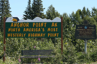
The drive out to Anchor Point also boasts the most Westerly Highway.  We have been to the most Southerly and the most Easterly and now the most Westerly in the U.S..


Along the road was the "Erector Set" Bridge as the locals refer to it.


Monday, July 29, 2013

Homer, Alaska


In Homer and having a blast.  It is so beautiful here.  Right now I am watching a Harbor Seal  swimming in the calm waters, just yards from the front of the coach.  We decided to take a drive around Homer (land side) and take some photos overlooking the bay, the spit and the mountains.

 
The highest point of Homer is about 800 feet

 
The campground is right there on the spit...  so cool
 
 
We've been feasting on fresh seafood and watching the fishermen pulling in and displaying their catch.  This was a full-day fishing trip for 6 guys.   The largest Halibut (the white fish) was 57 pounds and the largest Cod (left 2 brown fish) was 65 pounds - along with some other fish I don't know.
 
Celebrated Linda's Birthday here - looks out on the water
 
 
Weather people have extreme problems on the water and mountains figuring out what the weather is going to do.  Thought this was the most appropriate way to predict the weather....
 

Friday, July 26, 2013

Road to Homer

We saw more traffic in Anchorage than we had seen on the whole trip from Dawson Creek to Anchorage (1850 miles).   A trip to Costco - across the street from the campground, let us fill our cupboards, refrigerators and gas tanks.  But we were ready to get out of the big city and get on with our trip.

We traveled the Seward Highway to Tern Lake then jumped on the Sterling Highway.  The trip gave us breathtaking views almost the entire trip.

 
We drove along Turnagain Arm and Cook Inlet and had incredible snow covered mountain and glacier views


Portage Glacier in front of us 
 
 
Wild flowers, lakes, mountains and highway nearby
 
 
One of the many stops along the road


 This is one of the glacial rivers near Cooper Landing.  The river has copper in it and the glacier flour which gives it the milky blue/green color.


A short stop for road construction along a creek and we saw salmon swimming.  Steve wanted me to jump out of the coach and catch a few for dinner.
 
 
Homer Spit and the mountains in front.  So beautiful.  We couldn't get rid of the camper in front of us, so he became part of the blog. 
 
 
A "spit" is a peninsula jutting into a body of water that constantly changes land mass.  We are sitting between Kachemak Bay (Russian name means "high cliffs on the water") and Cook Inlet.  In the 1964 earthquake, the spit sank 4 to 6 feet requiring several buildings to be moved. 
 
The Homer Spit is a working port with the Alaska State Ferry System, Alaska Marine Highway, commercial fishing and fish processing. Homer calls itself the "Halibut Fishing Capital of the World".  Fishermen regularly catch Halibut weighing 300 pounds.
 
 If you have seen the TV show "The Deadliest Catch", one of the boats (Time Bandit) is docked and works out of Homer.


Steve, Linda and Lucy's first view from their campsite.  We were supposed to be here 4 days, but once we drove in, we decided to stay an additional 4.  Who could drive away from this view?

 
View from our campsite across Kachemak Bay

 
Views of the glaciers - just on the other side of these mountains are large glaciers, Harding Icefield and the Kenai Fjords National Park.  Post to come.
 

To Anchorage

We made our way to Anchorage on the Parks Highway.  The clouds parted for us and allowed us incredible views of Mt. McKinley.   We made many stops on our way to Anchorage.

 
This is only part of the range - the views were breathtaking.
The Athabaskan name for Mt. McKinley is Denali.

 
An Athabaskan first ancestor created Denali while in battle.  He turned his enemies ocean waves of anger into mountains.  The largest he named Denali, meaning "the high one".  The next largest he named Denali Be'ot meaning "wife" of Denali and Begguya (Mt. Hunter) is their child.

There is always a push to have the name put back to Denali, but there is a permanent pending legislation to keep the name Mt. McKinley. 

Monday, July 22, 2013

Denali

Denali is an Athabascan word which means "the High One" and Mt. McKinley dominates the 6 million acres of Denali National Park at 20,320 feet.  Gene says Denali means Big Mosquito. 


We drove into Denali with cloudy skies and periodic rains.  But the beauty of the park and mountains still shined.  Blue skies and clouds on the mountains.
 
 
A drive into the Park and views of the Alaskan Railroad Bridge and mountains.
The train brings tourists from Anchorage.
 
 
The views were beautiful  


Went to a Salmon Bake and "Cabin Fever" Revue at the Park Resort


Gene got a kiss from Miss Kitty...  notice the dollar in her hand?


 Mt. McKinley in the background - look real close - it was our first view.


Gene's camera did much better.  McKinley is 100 miles away from us and still towers over all the other mountains.
 
 
One river that flows through the Park is the Savage River. 
 
 
Back in "town" we stopped at the Salmon Bake and had lunch.  Notice the mile marker pole?  We are many miles from everyone.

 
A drive down the Nenana Canyon along the Nenana River.  This was a trip we made from the campground to Denali Park and the town of Denali.

 
The Nenana River is from glacier water.  As the glacier moves across rock, it grinds and pulverizes the rock.  This is what is called glacier flour and makes the river a milky color.  It is frigid and flows very quickly through this canyon.

 
The Stampede Trail near Healy, AK was an old mining road (50 miles) and a bus was left behind during road building to serve as a backcountry shelter. We drove out about 8 miles  This bus is a replica used in the movie "Into the Wild" which was about a man who tried to survive in the wilderness (didn't make it). 
 
 
The 49th State Brewery also had great drinks and food.  Steve had to show off his hamburger and beer.
 
 
Gene wanted a picture of his Reuben also...  so good.


Saturday, July 20, 2013

Fairbanks

We are in Fairbanks, AK (about 190 miles from the Arctic Circle).  We were going to drive up but it was suggested to carry two spare tires and there were limited services. No thanks!
 
The sun sets here at 11:50 PM and rises at 3:45 AM.  At 1:30 AM, it is as bright as an overcast, rainy day.   But each day loses about 7 minutes of light.  At Winter Solstice, there will only be 3.75 hours of light.
 
Downtown Fairbanks mile marker... 


It is on the Chena River next to a beautiful park
 
 
North Pole, Alaska and a visit to Santa's house.   Yes, there really is a Santa.


A drive out of town and a walk under the Alaskan Pipeline. The vertical silver fins keep the permafrost from thawing.
 
 
The silver line through the map shows where the Pipeline travels.
From Prudhoe Bay to Valdez.